It’s said to be the most isolated place in the world - further from the next civilized place than anywhere else in the world. It’s a five hour flight due west from Santiago, Chile. Locals call it Rapa Nui, but most Westerners know it as Easter Island.
Our planned early morning departure from Santiago was somewhat delayed, but we still arrived on Rapa Nui, two time zones to the west, in the early afternoon. Here’s a map of the island, borrowed from Wikipedia:

It’s not a big island, the airport runway, at the lower left, runs from the east coast to the west coast. This is a sculpture that greets you at the airport:

Honestly, at first glance, I thought it was a bug-eyed monster, but the proper way to see it is as two birds, belly to belly, beaks at the top. The significance of this will be clear later on. Immediately outside the terminal, we all got lei-ed (Sorry, couldn’t resist.):

The only town of any size on the island is Hanga Roa, which is adjacent to the airport. That’s where our hotel was located:


Below is the the hotel lobby, where I spent most of my free time:

This is the view from my room:

I’ll take you on a brief tour of Hanga Roa first. Here are my cousin, Tom, and me on the coastline near the hotel:

(For an introduction to people on the tour, see the Santiago post.) Most of Rapa Nui’s coastline is very volcanic:

Here are Tom, Kathy, and Paul exploring an inlet:

Here is the “main street” of Hanga Roa:

A banana tree along main street:

Dogs are everywhere on the island:

The Catholic church on the island is at one end of the main street:

and the largest market for native crafts is nearby:

Due to unchecked deforestation, trees are rare on the island today, and most of the buildings are built from stone, as is this small shop:

This is the sign in front of the shop:

At the other end of main street is the harbor:

where you get your first look at one of the moai that the island is famous for:

Tom decided to interview a couple guys making a modern moai:

There is a pool, protected from the waves:

Nearly all the good restaurants are on the harbor. We had a great open air lunch at one:

and a couple delicious dinners at others. At our first dinner on the island, I was surprised by the size and elaborate presentation of the caipirinha I ordered:

There was a gorgeous sunset from the restaurant that evening:

The figure on the left is a statue. Sebastian, our trip leader, got a gorgeous snap of the sunset:

The afternoon we arrived, there was time to take a quick excursion to one of the archeological sites, at the southeast corner of the island:

On the left is Sebastian and on the right is Noe (pronounced: No-eee), our local guide and a native of Rapa Nui. Noe appeared in the movie “Rapa Nui”, is married to man from Spain, and mother of two:

This area, and the entire island, are very scenic:

We got an introduction to our first in-situ moai:

Near the end of the moai era, there was a great war among the tribes of the island and most of the moai were toppled over:

Many of the moai originally had large topknots sitting on their heads, carved from a reddish stone:

On our way back to the van:

I got a picture of one of the natives:

Surprisingly, cattle are not widespread on the island.
If you refer to the map at the top of this post, there is one main road that loops up the east coast and back down the center of the island. On our second day, we traveled this in a counter-clockwise direction. Our first stop was Akahanga:

For English speakers, the letter that looks like a cross between “n” and “j” is a contraction of “ng”. Walking toward the site, we came across the bones of a horse:

There are many feral horses on the island. This is one of the moai that was toppled in the great war:

Talk about a face plant! I don’t know if this guy was luckier, or got turned over more recently:

This one is harder to see, but the rock behind me is a moai on its side:

Our next stop is the most impressive installation on the island:

This guy at the entrance is called the traveling moai, because he spent a while in Japan before being returned to the island:

Why Japan? I’ll tell you in a moment. The breathtaking feature of Tongariki is the ahu (platform) with 15 moai on it:


The largest moai stands almost 30 ft. tall and weights 86 tons.

Here I am, auditioning for number 16. What do you think?

We also got a great group shot here:

Like nearly all the moai of Rapa Nui, these were toppled face down in the great war among tribes. In 1960, an earthquake off the coast of Chile sent a tidal wave over Tongariki, washing the moai even further inland. In the early 1990s, a Japanese company gave Rapa Nui a crane to set all the moai back into the positions we see today. In return, the traveling moai was loaned to Japan for the Osaka World’s Fair. Only one topknot made it back onto a head, but several others are lined up off to the side:

Most moai installations are near the sea, but face inland. The idea is that they are protecting the village. The larger and greater number of moai, the more powerful the village. Moai are intended to represent past chiefs and elders.
Not far from Tongariki is the quarry where every moai on the island was carved:

A wood carving near the entrance:


At some point - probably the tribal war - production and delivery halted abruptly. Many moai are left unfinished or undelivered:


When I first saw them, I didn’t understand what these girls were doing, but then I realized that from the perspective of the photographer (nearer girl) the other one appears to be kissing a moai:

It’s a pretty good climb up the hill to the quarry itself:


As you can see, the moai were completely carved in place before being transported; there must have been a ritual reason for that. On the way back down, we could see Tongariki in the distance:

and we ran into this guy:

Friends tell me there’s a resemblance. He’s unique as the only moai in a squatting position:

Back near the entrance was an area where we ate a catered lunch:

The next site we stopped at had just one moai, but it is the largest:


Also in this area is a rock (the central one) that has a strong magnetic field and is believed to have magical powers:

A vendor’s table at this site bore this map of the old tribal boundaries:

This is the only place on the island that we saw this information; maybe it stirs up old rivalries.
We had one more stop to make before returning to Hanga Roa:

A treat they serve here is a small pineapple with its outer husk shaved off, the leaves wrapped in a paper towel, and eaten like an ice cream cone:

Anakena has its own set of moai, most with the topknot in place:

The big attraction here, though, is one of the two good beaches on the island:

We had time for a nice, refreshing wade and some sun.
The next morning we were off to a very special place at the southwestern corner of the island:

Here we learned that at some point the inhabitants of Rapa Nui gave up on the moai for protection (probably after they had all been toppled over) and quickly invented a whole new religion, based on the worship of birds. (Remember the bird sculpture at the airport?) Here are some terms associated with this new religion:

The Sooty Tern was of particular importance. Each year they return from migration to nest on a small island off of Rapa Nui. This would signal the start of a contest. The best athletes on the island scaled down a cliff, swam to the largest of the islands you see below:

and waited for the first tern egg to be laid. The lucky one to find it would swim back, climb up the cliff, and present the unbroken egg to his sponsor (tribal chief or provider), who then became the Birdman of the year, the holiest person on the island. Okay…
Nearby are a number of low stone houses used by the priestly class:


and around the corner from those is a large volcanic crater:

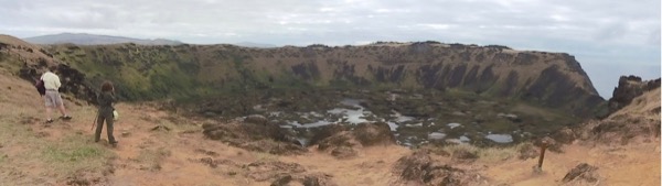
If you look at the map at the top of this post, you can see this crater at the southwest corner of the island.
Driving back from Orongo, we stopped to appreciate a view of Hanga Roa:

Also along the drive is a lone moai that was somehow involved in the astronomical calendar for the island:


Behind the moai is a crematory, but it was never used:

We also stopped where all the topknots for moai were quarried from reddish stone:


Following lunch back in Hanga Roa, we were off again:

The moai here are unique in that they face the sea rather than the land, perhaps to commemorate some great voyage:


We then circled back to our last stop, on the northern outskirts of Hanga Roa:


On the stone in the foreground is a plaque that commemorates the archeologist who did some of the earliest and most extensive studies on Rapa Nui:

There are more of the low stone priestly houses:

and also examples of houses for the common people:

The holes in the stone foundation are for bent branches that form a shelter the shape like the hull of an overturned boat. Here’s an overview of the rest of the site:

a group of moai, a couple singles, and a boat ramp between them dating to the same era.


The moai above is the only one on the island that has white coral eyes reinstalled. Originally, all moai had them. Our tour group had a farewell party nearby, and as the sun set, I came back for one last photo:

The next day we were on our flight departing one of the most interesting places I’ve ever been. But it was just the end of the beginning of our tour. Ahead lay Buenos Aires.
No comments:
Post a Comment